White Mountains Area
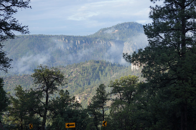
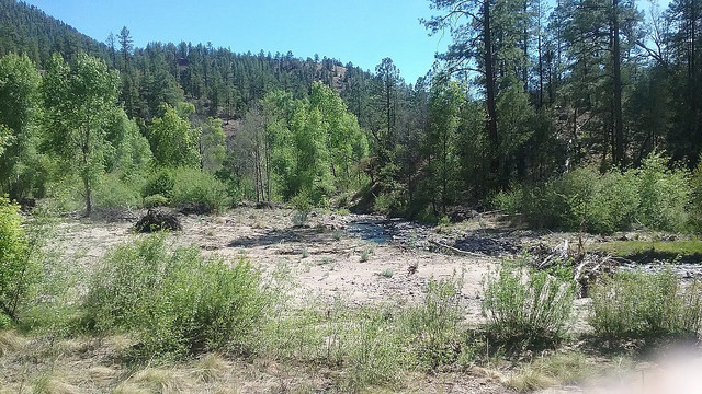
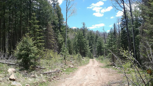
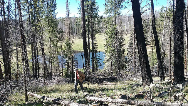
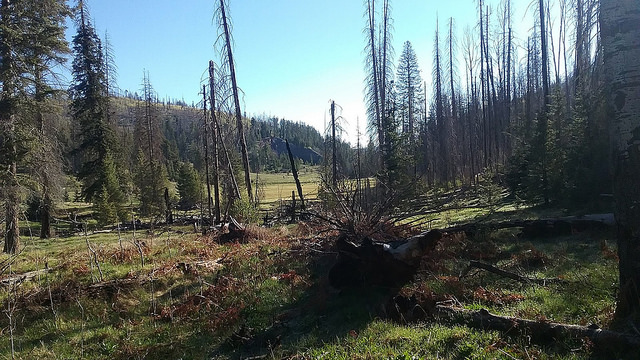
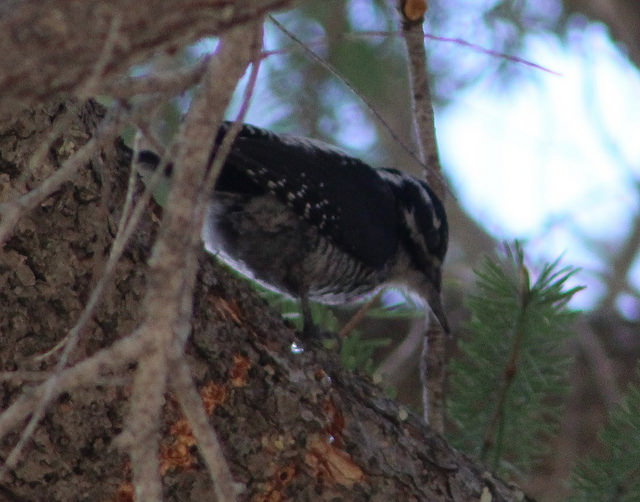
The White Mountains are home to some of Arizona's highest elevations. Habitat that is similar to the Rocky Mountains above the Colorado Plateau, stretches over to east-central Arizona in the White Mountains. Some think that it's an extending chain of the Rocky Mountains. While most of the White Mountain region lies in Apache County, some of it extends down into Greenlee County. This area of Greenlee County is home to several species of birds in Arizona that can be harder to find elsewhere in the state, with those birds including Dusky Grouse, Gray Jay, American Three-toed Woodpecker, and American Dipper. Aside from these mentioned, a variety of other bird species who favor high elevation forests can be found within the Greenlee County portion of the White Mountains also. This area really extends such incredible habitat diversity found in a small county like Greenlee with stands of spruce, fir, pine, and aspen. Sadly, the 2011 Wallow Fire burned an Arizona wildfire record of over 530,000 acres in the White Mountains. The Greenlee County section was torn up in many places, and it's difficult to find places without burn in these higher elevations. However, fires burn in patchy ways and there are still great stands of habitat to bird, and the birds are still numerous. While this area is mostly made up of high elevation mixed coniferous and aspen forests, the habitat drops in elevation drastically in the canyons and valleys that harbor the Upper Blue River. The Blue River rivals the higher elevations in this area with a scenic beauty of it's own.
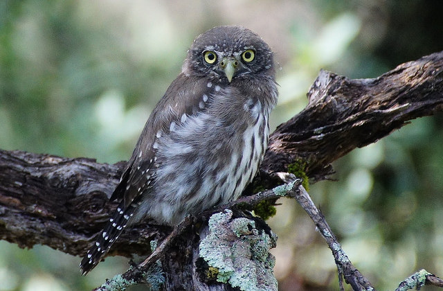
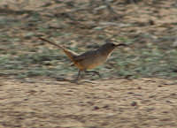
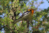
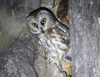
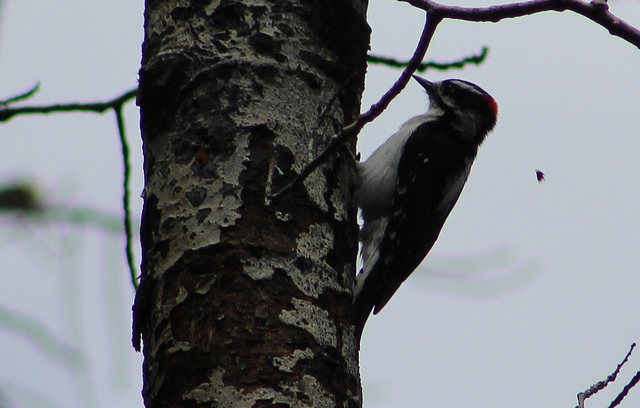
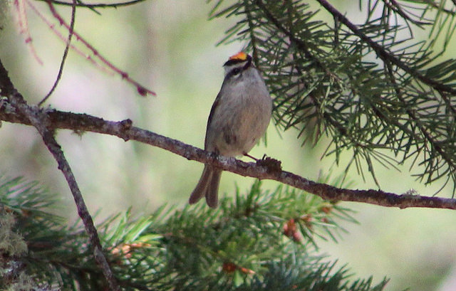
Birds and habitat you may see in the White Mountains Area: The habitat in the White Mountains area is incredibly variable. Most of this area is made up of coniferous forest, but the area within the Blue River holds habitat that includes cottonwood and willow riparian, scrub oak, pinyon and juniper stands, rocky bluffs and cliffs, and lush canyons and creek drainages that have mixes of pine, oak, and Douglas fir. As mentioned above, the Wallow Fire burned thousands of acres of forest, and the burned forest benifits some bird species, such as American Three-toed Woodpecker. The higher elevations of the White Mountains area has Great Basin grassland within coniferous and aspen forest. Coniferous forests in this area are found within a wide range of different elevations. At the higher elevations that go above 9,000', there are fine stands of spruce, fir, pine, and aspen. Breeding birds that are dependant on spruce and fir and these higher elevations that exceed 9,000' include Dusky Grouse, Sharp-shinned Hawk, American Three-toed Woodpecker, Clark's Nutcracker, Gray Jay (status uncertain, likely very rare in region with loss of habitat), Golden and Ruby-crowned Kinglets, and possibly Evening Grosbeak. There are a lot of breeding birds that prefer a variety of forest types. Some species do prefer spruce, fir, and aspen at higher elevations but also prefer elevations down to what are mostly ponderosa pine forests. These habitats also have riparian along creeks and rivers, tanks and ponds with water, open forest edges such as grassland, and canyons with a mix of pine and fir at elevations from roughly 7,500' to about 9000'. This variety of birds include Wild Turkey, Northern Goshawk, Red-tailed Hawk, Band-tailed Pigeon, Flammulated Owl, Northern Pygmy-Owl, Spotted Owl, Northern Saw-whet Owl, Common Nighthawk, Broad-tailed Hummingbird, Williamson's and Red-naped Sapsuckers, Downy and Hairy Woodpeckers, Northern Flicker, Olive-sided Flycatcher, Western Wood-Pewee, Cordilleran Flycatcher, Plumbeous Vireo, Warbling Vireo (aspen stands), Steller's Jay, American Crow, Common Raven, Violet-green Swallow, Purple Martin, Mountain Chickadee, Red-breasted and White-breasted Nuthatches, Pygmy Nuthatch, Brown Creeper, House Wren, Western and Mountain Bluebirds, Townsend's Solitaire, Hermit Thrush, American Robin, Olive Warbler, Virginia's, MacGillivray's, Yellow-rumped, Grace's, and Red-faced Warblers; Chipping and Vesper Sparrows, Dark-eyed Junco, Green-tailed Towhee, Western Tanager, Black-headed Grosbeak, Red Crossbill, and Pine Siskin. The canyons and valleys that harbor the Blue River really add to the habitat diversity in this area, as the Blue River nearly flows through the eastern side of this area from north to south. There is a lot to explore. Elevation along the access points to the Blue River vary from 5,100' to 6400'. Riparian habitat along the Blue River is dominated by stands of cottonwoods. In this habitat, breeding birds to look for include Common Black Hawk, Zone-tailed Hawk, Black Phoebe, Ash-throated and Brown-crested Flycatchers, Cassin's Kingbird, Bridled Titmouse, Yellow Warbler, Song Sparrow, Yellow-breasted Chat, Summer Tanager, Blue Grosbeak, Hooded and Bullock's Orioles, and Lesser Goldfinch. In rocky bluffs and cliff areas, birds to look for include Golden Eagle, Peregrine Falcon, Montezuma Quail, Rock Wren, and Canyon Wren. Scrub oak, pinyon-pine, and juniper may host Western Scrub-Jay, Pinyon Jay, Gray Flycatcher, Bewick's Wren, Juniper Titmouse, Bushtit, Black-throated Gray Warbler, Rufous-crowned Sparrow, and Scott's Oriole as several examples. On mountain slopes, canyons, and drainages above the Blue River, there are forests that consist of ponderosa pine, Douglas fir, Gambel's oak, and more in the midst of these other habitats mentioned, most of which fall below 7,000' in elevation. These draws host excellent birding opportunities. Birds to keep an eye and ear out for include Montezuma Quail, Cooper's Hawk, Flammulated, Northern Pygmy, and Spotted Owls; Common Poorwill, Mexican Whip-poor-will, Acorn Woodpecker, Greater Pewee, Dusky and Cordilleran Flycatchers, Hutton's and Plumbeous Vireos, Mexican Jay, Bridled Titmouse, White-breasted and Pygmy Nuthatches, Virginia's, Grace's and Red-faced Warblers; Painted Redstart, Hepatic and Western Tanagers, and Black-headed Grosbeak. The birds mentioned are what falls in line for those who are breeding in the area. By exploring this area thoughout the year, especially during spring and fall migrations, there are bound to be interesting birds that will pass through the White Mountains. Winter is another interesting time of year. Although activity would be much lower, exploring the area may result in some surprises.
Area Elevation: The White Mountains area has a wide range of elevations that go up as high as 9400' in places and also go as low as 5100' in other places within the Blue River. Elevation will be included for each location described.
Base Point for directions: Hannagan Meadow is the most well known community in northern Greenlee County. It will be used as the primary base point for directions in this area. The Hannagan Meadow label on the map actually falls barely north of Hannagan Campground, which is just south of Hannagan Meadow Lodge. Another point that will be used will be the community of Alpine, which is shortly north of Greenlee County and is in Apache County. A few locations in this area can be described by using Alpine as a base point. Alpine is 23 miles north of Hannagan Meadow via Highway 191 and it's official spot on the map is at the junction of Highways 191 and 180.
Area Maps: White Mountains Area Maps
Birding Locations:
1. Turkey Creek and Campbell Blue Creek: These two creeks have good birding and are just north of the Blue River. An easy way to access them is by taking Highway 191 from Hannagan Meadow to the north for 23 miles to Alpine. Turn east (right) onto Highway 180, and head east on 180 for 3.2 miles. Turn south (right) onto Blue River Road and head south. Blue River Road turns into Forest Road 281. For the first 4.3 miles of heading south on Blue River Road/Forest Road 281, one is in Apache County before entering Greenlee County after those first 4.3 miles. Once entering Greenlee, the road drops considerably into the canyons and valleys where the Blue River and several creeks are with windy twists and turns. This is a gorgeous area, and a flowing Turkey Creek soon parallels the west side of Forest Road 281. At 7.9 miles after driving south on Blue River Road/Forest Road 281 from Highway 180, 281 intersects with Luce Ranch Road. Another creek, called Campbell Blue Creek, parallels the south side of Luce Ranch Road to the west. Campbell Blue Creek displaces Turkey Creek and eventually flows into the Blue River after 1.9 more miles of driving. Contining on Forest Road 281 east past Luce Ranch Road will result in 281 dipping shortly east into New Mexico before curving back into Arizona after 9.5 miles of driving on 281 south from Highway 180. Once the road turns back into Arizona, the Blue River then parallels Forest Road 281 for miles to come (see the Blue River section for more information on birding it). Turkey Creek and Campbell Blue Creek are very promising. Park and bird along many areas along both. Forest Road 281 via Turkey Creek is especially promising. Birding Luce Ranch Road west of it's intersection with Forest Road 281 is too. Alongside these creeks are surrounding hills that are filled with scrub oak and juniper while canyons and drainages in the area contain ponderosa pine, oak, and Douglas fir. Sections along the creek have riparian habitat that have large groves of cottonwood trees. For the White Mountain region, it brings a different cast of birds than what is usual and that cast may include Greater Pewee, Bridled Titmouse, Painted Redstart, and Summer Tanager in elevations that are still relatively high at 6,500' to 7,000'. Other birds that may be seen include Wild Turkey, Northern Pygmy-Owl, Acorn Woodpecker, Cordilleran Flycatcher, Cassin's Kingbird, Plumbeous and Warbling Vireos, Steller's Jay, Clark's Nutcracker, Purple Martin, Bushtit, White-breasted and Pygmy Nuthatches, Brown Creeper, Rock and Canyon Wrens, Blue-gray Gnatcatcher, Hermit Thrush, Virginia's and Red-faced Warblers, Yellow-breasted Chat, Rufous-crowned Sparrow, Hepatic and Western Tanagers, Bullock's Oriole, and Red Crossbill. Night birding will give one an excellent shot at Spotted Owl, Flammulated Owl, Common Poorwill, and possibly Mexican Whip-poor-will. From the road, walk up many side drainages, some of which have flowing water, that include lush stands of pine, fir, and oak. Red-faced Warbler and Painted Redstart are common. Continuing east on Forest Road 281 past the intersection of Luce Ranch Road takes one into more riparian habitat, with cottonwood as the dominant tree along the creek. Just after crossing into New Mexico, Campbell Blue Creek crosses Road 281 and is often too deep for vehicles to cross at certain times of the year. Do not attempt to cross the creek if the water conditions are sketchy.
2. Lower Forest Road 59 (Crow Poison Road): This road is at the northern tip of Greenlee County for about 6.3 miles before going north into Apache County. From Hannagan Meadow, take Highway 191 north for 16.5 miles (or take Hannagan Meadow south from Alpine on Highway 191 south for 6.4 miles) and this road will be on the east side of 191. The road is slightly in Apache County before immediately going south into Greenlee County. After dipping south and then curving up to the northeast after about 6.3 miles, the road goes back into Apache County. At 2.7 miles, the road dips down into an interesting forested canyon. The canyon looks very interesting to explore, and it goes north for about 0.8 miles from the road before it crosses into Apache County. To the north of this road are several other roads labeled 59, 59F, and 59E, all in Apache County. The elevation along FR 59 is about 8000' up until one reaches the mentioned canyon. Further east past the canyon, the elevation increases as the road climbs to 8900' before it enters Apache County.
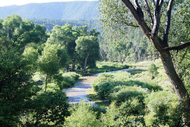
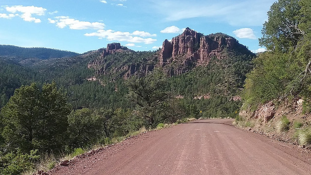
3. Red Hill Road (FR 567) and Upper Blue River: From Hannagan Meadow, take Highway 191 north for 8.7 miles and turn east (right) onto Red Hill Road, which is also known as Forest Road 567. Red Hill Road is an excellent road for birding, and it heads east and drops significantly in elevation when it crosses the Blue River after 12 miles and intersects with Blue River Road (Forest Road 281). The twelve miles of Red Hill Road starts off in ponderosa pine and oak forest for it's first few miles and it then drops down into pinyon-juniper, rocky bluffs, cliffs, and scrub-oak until it eventually meets and ends at Blue River Road. On Red Hill Road, elevation starts off at roughly 8100' which continually drops down to 5800' at the Blue River. Look for a variety of birds along the drive on Red Hill Road that include birds typical of pine and oak forest and birds like Peregrine Falcon, White-throated Swift, Woodhouse's Scrub-Jay, possibly Pinyon Jay, Gray Flycatcher, Black-throated Gray Warbler, Rufous-crowed Sparrow, and Spotted Towhee in the pinyon-juniper, rocky areas, and scrub before the Blue River. The Blue River has incredible birding and hiking opportunities and it needs to be birded for a full day or two because it is a big area with a lot of potential. Breeding birds along the Upper Blue River and it's surrounding habitat include Montezuma Quail, Common Black Hawk, Greater Pewee, Steller's Jay, Bridled Titmouse, Bushtit, Pygmy Nuthatch, Virginia's, Red-faced, Grace's, and Yellow Warblers; Painted Redstart, Yellow-breasted Chat, Western, Hepatic, and Summer Tangers, Black-headed Grosbeak, and Bullock's Oriole. For the Blue River, directions will be written for different locations along Blue River Road/Forest Road 281 from either north of the intersection with Red Hill Road or south of the intersection with Red Hill Road. The Blue River has elevation change from the north point to the south point within this location being 6400' down to about 5100'.

Blue River Road/FR 281 (North of Red Hill Road)
3.1: Blue Crossing Campground: This is an exception to what was said about directions whether they were north or south of Red Hill Road. This campground is on the north side of Red Hill Road, and barely west of the Blue River and Blue River Road. Park or camp here. The campground is in midst of a large grove of cottonwoods.
Blue River via Red Hill Road Crossing on eBird
3.2: Blue Elementary School: This school is on the east side of FR 281 and the Blue River, 0.8 miles north of Red Hill Road, and is an interesting location. A library for the community of Blue is also present. Don't interfere with school activities while school is in session. Follow a road to the east past the school and library to stands of pine and oak. Greater Pewee is among the many birds that may be present here.
Blue River Road via Blue School on eBird
3.3: Swafford Canyon: After 3.1 miles of driving north on FR 281 from Red Hill Road, the Blue River is in midst of Swafford Canyon. It is a lush riparian area, with shady canyon walls around it. Thick riparian habitat is found on both sides of the road.
3.4: Upper Blue Campground: 6.1 miles north of Red Hill Road on FR 281 is Upper Blue Campground, on the west side of 281, but east of the Blue River. Pine and oak line the road and cottonwood riparian lines the Blue River. Dusky-capped Flycatcher was found here in May of 2017, perhaps a first for the White Mountain region.
Upper Blue Campground via Blue River Road on eBird
3.5: New Mexico: After 8.7 miles of driving on FR 281 north of Red Hill Road, the Blue River is near it's northern limit and FR 281 goes into New Mexico shortly. It goes back into Arizona, but once in Arizona again, the Blue River has reached it's northern limit, and FR 281 parallels Campbell Blue Creek and then Turkey Creek as it goes toward Highway 180 in Alpine, as well as Apache County. For more information on this area, look at the first location mentioned within this birding area.
Blue River Road/FR 281 (South of Red Hill Road)
3.6: Blue: After 1.6 miles of heading south on FR 281 south of Red Hill Road, FR 281 intersects with Peublo Park Road. Peublo Park heads east and 281 makes a sharp turn to the west and enters the small and interesting community of Blue. There is a post office here and an old bar. Some farm fields and ponds can be seen from FR 281 but are on private property.
3.7: Blue Camp Trailhead and Lanphier Canyon: After 3.6 miles of heading south on FR 281 south of Red Hill Road, Blue Camp Trailhead and Lanphier Canyon are on the south side of 281 and Lanphier Canyon is on the south side of the Blue River. Look for a trail to hike from the trailhead, and Lanphier Canyon has had good birding in the past, including Montezuma Quail.
Lanphier Canyon on eBird
3.8: End of FR 281: After 13.4 miles of driving south on FR 281, the road dead ends at Private Property. Between this ending point and at the previous point mentioned that included Lanphier Canyon, there are plenty of places along the Blue River that are worth exploring.
4. Forest Roads 26 and 574: These two forest roads are accessed north of Hannagan Meadow on the west (left) side of Highway 191: Forest Road 574 is 6.8 miles north of Hannagan Meadow, and Forest Road 26 is 8.7 miles north of Hannagan Meadow. Both of these roads head in the western direction into the White Mountain wilderness toward the Black River, but these roads don't reach the Black River before they end at other roads that do reach the river. The Black River represents the county line of Greenlee and Apache Counties. Both Forest Road 26 and 574 go through coniferous and aspen forests and are worth birding along many roadside locations. Aside from these two roads are many other forest roads in the area that branch off in different directions and are also worth exploring. Within the first few miles of Forest Road 26, it has branch off Forest Roads 37B and 37C, which head north to join FR 37. Beaver Creek will also parallel FR 26 to the south. Keep left to stay on FR 26, as all of the other roads within these first miles will branch north and right. At 5.3 miles, FR 26 interests with FR 574 (574 will be described in latter half of description). For up to 10 miles, continue on FR 26 until it ends at FR 24 (another birding location). Grassland meadows will join the conifer and aspen forests as one explores FR 26 to it's ending limit. Forest Road 574 will be quite similar to FR 26. At 1.7 miles of driving on 574, the road crosses Hannagan Creek, which flows north to the northwest and into Beaver Creek (which is just south of FR 26). At 4.3 miles of driving, a road branches off 574 and heads northeast for just over a mile out into open meadows and Taylor Pond and Spring. At 5.3 miles, FR 574 intersects with FR 26. At 5.9 miles, a dirt road heads east to Beaver Creek Ranch, and at 6.8 miles FR 574 reaches it's northern limit and ends. The northern half mile of FR 574 has Beaver Creek paralleling shortly to the east. Elevations of these roads range from 7500' to 8100'.
5. Forest Roads 576, 24, and 83: These three forest roads are north and south of Hannagan Meadow, and each will be described. They have junctions with each other and have routes that take one to the Black River, the western limit of the White Mountains section of Greenlee County. All have live and burned areas, with the burned areas being from the 2011 Wallow Fire.
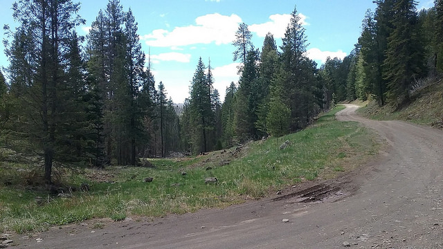
Forest Road 576 is 0.5 miles north of Hannagan Meadow and is on the west (left) side of Highway 191. It goes through a beautiful section of spruce, fir, pine, and aspen forest that also has grassland and meadows mixed in. Forest Road 576 ends in 4 miles at a junction with Forest Road 24. After 2 miles, FR 576 goes through burned area after the first 2 miles go through the mixed conifer forest. After 0.8 miles of driving on FR 576, look for a side dirt road that branches off to the the north when FR 576 takes a sharp turn to the south. This dirt road is 1.3 miles long, and it goes north and then loops back south to join FR 576 again, with the second and northern fork of the road being 1.6 miles past Highway 191 on FR 576. This side dirt road can be driven for about 0.6 mile from it's south fork before further vehicle access is prohibited. Foot travel is allowed, and if one wanted to hike this side road in it's entirety, and return on FR 576 for 0.8 miles, it would be a pleasant 2.1 mile loop hike. The side road also takes one out to an old abandoned homestead as well as Baike Spring after a half mile, which has a few small ponds out on the open meadow in the area. Elevation ranges from 9000' to 9250'.
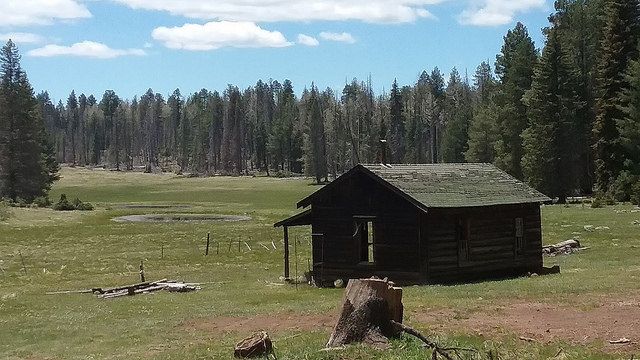
Forest Road 24 is accessed via Forest Road 25 from Highway 191. From Hannagan Meadow, take Highway 191 south for 4.7 miles and Forest Road 25 is on the west (right) side of the road. Forest Road 24 is acessed after driving 0.5 miles on FR 25 and will be on the right side of FR 25. FR 25 will be another location described for this area, but FR 24 heads northeast and falls in line with the roads and area within this location. FR 24 runs for 16.5 miles to the northeast until it reaches the Black River. Once at the Black River, the road crosses into Apache County, becomes a different road labeled Rt 25J, and enters the Apache Indian Reservation. If birding the Indian Reservation from this point, be sure to have a day use permit for recreation (these permits can be purchased at Sunrise and other locations further west on Highway 260 in Apache County). At 6.7 miles after turning on FR 24 from FR 25, FR 24 will intersect with Forest Road 576. Taking FR 576 to FR 24 may be a much better way to access FR 24. The remainder of the directions for this road will be used from this intersection of Forest Roads 24 and 576. 0.6 miles past the FR 24 and FR 576 intersection is access to the south fork of Forest Road 83. At 11.9 miles of driving on FR 24 past FR 25 (5.2 miles past 576/24 Junction), is the northern fork of Forest Road 83. At this point, FR 24 will soon be bordered by the Black River on the north and west side of the road for the remainder of it's length. The east side of the Black River is Greenlee County, and the west side of the river is Apache County. As mentioned before, the Apache County side of the river is on the Fort Apache Indian Reservation and a permit is needed for recreational use. 6.8 miles on FR 24 past it's junction with FR 576 is the intersection with FR 26 (part of the previously described location). 8.1 miles past Road 24/576 junction is Forest Road 565. This road has Beaver Creek paralleling to the south, and after a mile of driving east on 565 past 24 is Sprucedale Guest Ranch, another lodging option for a Greenlee County trip. Continuing another 1.8 miles on FR 24 (9.7 miles past FR576), its ending limit is reached at the Black River crossing before it enters the Indian Reservation. Just before the Black River crossing is a road going to Buffalo Crossing Campground on the east side of the river and still in Greenlee County. Another 0.8 miles north of this campground is Apache County, and the county line from here to the east of the Black River is a straight line west to east all the way to Highway 191. Elevation of FR 24 ranges from 9150' down to 7500'.
Forest Road 83 is a seven mile route that is accessed from FR 24, with elevations ranging from 7450' to 8900'. There are two forks to FR 83, both accessed from FR 24. The south fork is accessed from FR 24, which is 0.6 miles north of the junction of FRs 24 and 576 (our previously described roads). The north fork of FR 83 is 5.2 miles north of the junction of 24 and 576. Forest Road 83-A is a road accessed from Road 83, 3.6 miles after driving on FR 83 from the south fork of FR 83 via FR 24, or 3.3 miles of driving on FR 83 from the north fork of FR 83 via FR 24. 83-A is 3.3 miles in length, and at it's ending point, it has Fish Creek to the west. Fish Creek is known for being an outstanding wildlife area in a forested canyon, and one can follow Fish Creek to the north and down until it flows into the Black River. A lot of the habitat surrounding Fish Creek survived the 2011 Wallow Fire. It is here there is also a trailhead called Fish Creek Access Trail # 320. Follow the trail for best access. It is a 5.5 mile hike north to the Black River from here along the Fish Creek Trail, and the elevation drops considerably.
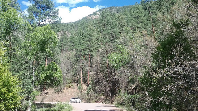
6. Hannagan Meadow: Hannagan Meadow, community and the base point of the White Mountains area, has excellent birding. Spruce, fir, pine, and aspen forest make up the area, which is rougly at 9-9100' in elevation throughout. Hannagan Meadow on the map falls right in line with Hannagan Campground, a popular ten site campground on the west side of Highway 191. The campground loop is worth walking and birding. Between sites 6 and 7 in the campground, is the trailhead for the Aker Lake Trail. There are a few parking spaces available for the trail. This trail goes through dense forest to the south for 3.5 miles to Aker Lake (another location in this area). Dusky Grouse, Gray Jay, American Three-toed Woodpecker, Clark's Nutcracker, and Downy Woodpecker are a few of the birds that have been found in Hannagan Campground or along the Aker Lake Trail. Adjacent to the campground turnoff on the east side Highway 191 is the Steeple/Foote Creek Trailhead. 0.2 miles north and on the west side of Highway 191 is Hannagan Meadow Lodge and Restaurant. This lodge would be a good place to stay if wanting to bird in this area for an extended time.
Hannagan Meadow Recreation Area on eBird
Hannagan Meadow Campground on eBird
Hannagan Meadow Lodge on eBird
7. Aker Lake Area: Aker Lake is a tiny lake that is formed by Fish Creek, and is south of Hannagan Meadow. It is known for it's fishing and hosting Arctic Grayling. The lake is in midst of a meadow that is surrounded by conifer and aspen at an elevation of roughly 8900'. Purple Martin and Violet-green Swallow utilize the lake. In the surrounding forest, listen for the drumming of American Three-toed Woodpecker. There are live and burned areas surrounding the lake. Forest Road 25-B, which is a loop road that has a north point and a south point, both accessed from Highway 191, accesses Aker Lake. From Hannagan Meadow, head south on Highway 191 for 1.9 miles and look for a dirt road (may be unmarked from Highway) on the west (right) side of Highway 191. This is Forest Road 25-B. Take 25-B for 1.1 miles until another dirt road forks to the right. This dirt road heads west for a short distance and down to Aker Lake. Past the west fork road that goes to Aker Lake, continue south on 25B for 2.5 more miles to Highway 191 to complete the loop. Where the southern part of FR 25B comes out at Highway 191, that will be 2.5 miles south of Hannagan Meadow. The northern access point of 1.1 miles of FR 25-B up until Aker Lake is reached is a more pleasant stretch than the last 2.5 miles/southern access point of 25-B. The southern point drives through what is mostly burned forest from the Wallow Fire. The northern stretch is beatiful and most of the habitat is still intact.
8. KP Cienega Campground: The turnoff to this campground is on the east side of Highway 191, 4.6 miles miles south of Hannagan Meadow. Follow this dirt road for 1.5 miles down into the campground area. The area has open meadow and forest of spruce, fir, pine, and aspen at elevation averaging 9,000'. There are burned areas within the forest. The campground and it's immediate surrounding conifers offer pleasant birding. Just north of the campground is a pond called KP Tank, and KP Creek to the northeast. The creek can be followed for a distance and is worth exploring, as it drops in elevation from 9,000 to 7,700'. This is a great area for hearing the drumming of American Three-toed Woodpecker. Dusky Grouse has also been found in the area. A variety of forest birds to look for include Hairy Woodpecker, Northern Flicker, Stellar's Jay, Violet-green Swallow, Brown Creeper, Golden and Ruby-crowned Kinglets, Western and Mountain Bluebirds, Red-faced Warbler, and Green-tailed Towhee.
KP Cienega Campground on eBird
9. Forest Roads 25 and 54: These are two more dirt road areas heading west into wilderness areas in the White Mountains in coniferous forests and mountains. Both are worth exploring. There are live and burned areas along both roads, but there looks to be a lot more live habitat.
Forest Road 25 is accessed 4.7 miles south of Hannagan Meadow on Highway 191, where it will be on the west (right) side of the road. It goes for 14.6 miles through Greenlee County until it reaches the Black River and enters Apache County, and the Apache Indian Reservation. There are several side forest roads along this main FR 25, as well as Conklin Creek, Conklin Creek Campgrounds, and Bear Wallow Creek. Consult a map to see all of these roads. This road is all about exploration and finding where the birds are! Elevation ranges from 9250' at the start of 25 down to 6900' where 25 meets the Black River.
Forest Road 54 is accessed just south of FR 25 on the west side side of Highway 191, 5 miles south of Hannagan Meadow. The length of FR 54 is 6.5 miles. At 4.3 miles of driving, a lesser dirt road branches to the southeast and heads to Mcbride Trailhead and accesses a hiking trail. Elevation of FR 54 ranges from 8500' to nearly 9300'.

10. Blue Peak, Highline, and Lengthy Trailheads; Stray Horse Campground: These four sites are worth birding and hiking, are in close distance of each other, and all are south of Hannagan Meadow. All of them have mixed conifer habitat, but especially ponderosa pine. There are some aspen stands in the northern spots and oak in the southern spots. The northern most of the four is Blue Peak Trailhead, which is much further off of Highway 191 than the other three spots. To get to Blue Peak Trailhead, take 191 south of Hannagan Meadow for 6.1 miles. A dirt road will be on the east side of Highway 191 at 6.1 miles. Take this road for 4.3 miles to Blue Peak Trailhead as it passes through both live and burned stands of mixed conifer and aspen at elevations from 8900' to over 9200'. The Highline Trailhead and Strayhorse Campground, both on the west side of Highway 191, are very close to one another. Highline Trailhead is 10.2 miles south of Hannagan Meadow on 191 and Stray Horse Campground is 10.3 miles south of Hannagan Meadow on 191. Adjacent to the east of Stray Horse Campground and on the east side of 191 is another trailhead called Raspberry Trailhead. These locations are situated at elevations of roughly 7800'. Finally, 13 miles south of Hannagan Meadow on Highway 191 is Lengthy Trailhead, which is on the east side of 191. Lengthy Trailhead and it's surrounding area is made up of pine and oak forest, and is at an elevation of 7200'.
Area Maps: White Mountains Area Maps
Back to Greenlee County Birding Areas |