San Carlos Apache Reservation
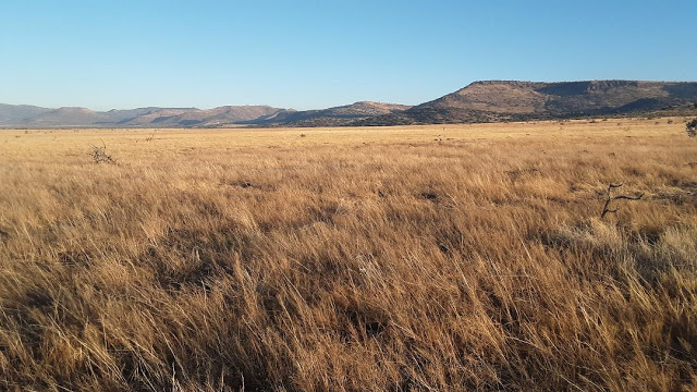
This area will cover the southern portion of the Gila County side of the San Carlos Apache Reservation. By the means of southern portion, it is referring to the birding locations that are found along or near Highway 70, which are east of the city of Globe west of the town of Safford. This is an area that is composed of various forms of desert-scrub communities as the main habitat makeup for the area. In midst of the desert habitats, there are some awesome habitats to bird that include open water, riparian woodland, and grassland. The vast San Carlos Lake is one of the best bodies of water to bird in Arizona. It's varying water levels over the course of it's length attract thousands of waterbirds annually, and it is a popular location on the Indian reservation for boating, fishing, and other outdoor related activities. Talkalai Lake is another lake in this area that is worth visiting, and it isn't far north from it's much larger neighbor that was just formerly mentioned. North of Highway 70 and near the main town of San Carlos are a handful of tanks scattered throughout the reservation. One of them, which is called Tufa Stone Tank, is extremely productive when it has water. It is a drawing card for this area and if it has water, it is one of the best birding locations in all of Gila County. The San Carlos River brings fourth impressive willow and cottonwood riparian woodlands that have neighboring mesquite bosques nearby. Although these habitats are impressive, the understory of these taller trees are dense and the San Carlos River is hard to navigate. Most of the birding has to be done from the outskirts of the river. On the eastern side of Gila County in this area, Warm Springs Flat respresents an excellent source of semiarid grassland to explore in midst of Chihuahuan desertscrub. General elevations in this entire area average 2,500' but go up to 4,000'. The San Carlos Reservation requires a ten dollar permit to bird on it's lands per day.
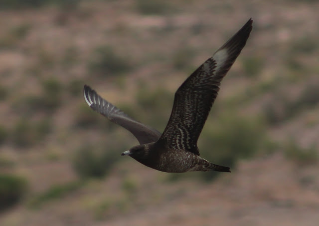
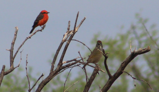
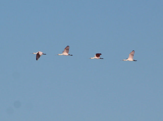
When birding on the San Carlos Apache Reservation, birders most often go to check San Carlos Lake during migration periods or in winter. While these are popular times for birding, a lake the size of San Carlos harbors the potential to produce surprises and good birding at any time of the year. Western and Clark's Grebes breed on the lake, and Bald Eagles can be found throughout the year at the lake and nearby. Spring and fall migration can have spectacular birding at any time of the year at San Carlos Lake. Look for gulls, terns, shorebirds, different herons, ducks, geese, shorebirds, and more. The Parasitic Jaeger photographed below was found at the lake in September of 2018. In winter, the lake is also very productive. In desert and riparian habitats, breeding birds are typical to those that are found throughout central Arizona in such habitats. For some species of note, Cassin's Sparrow has been found singing in numbers at the edge of Tufa Stone Tank, Pyrrhuloxia has been found north of San Carlos Lake near the San Carlos Sewage Ponds, and Northern Beardless-Tyrannulet has been found along the San Carlos River at and south of Talkalai Lake in mesquite bosque. The thick marshes that surround Talkalai Lake are probably the only place in Gila County to find Least Bittern, and they are also good for finding scarcer Gila County birds like Sora, Virginia Rail, and Common Gallinule. Tracing over to the east side of this area where there are solid sections of semiarid grassland at and near Warm Springs Flat, they are worth exploring for grassland populations of breeding birds like Cassin's Sparrow. In the fall and winter, the grassland is worth exploring for longspurs, Sprague's Pipit, Ammodramus sparrows, and Short-eared Owl. In Chihuahuan desert adjacent to these grasslands, a few flocks of Scaled Quail have been found. This was an area that wasn't known for quail prior to a recent visit. To sum this area up, the best birding opportunites that will come on this area will be in migration. On a scale that goes Gila County-wide, this area holds the best potential for finding rare and unusual birds throughout the year.
Directions and Access: At the eastern side of Globe, permits for the San Carlos Apache Reservation can be purchased for $10 at the Circle K at: 2011 E Ash Street, Globe, AZ 85501. Circle K is 1.3 miles west of the Highway 70/77 intersection. The main base point for the directions in this area will be from the Highway 70 and Highway 77 intersection just east of Globe. Heading east of the Highway 70/77 intersection for 17 miles on Highway 70, Peridot will be reached. One can go north to the town of San Carlos or south to San Carlos Lake from here. Peridot will be used as another common direction point for this area.
BIRDING LOCATIONS
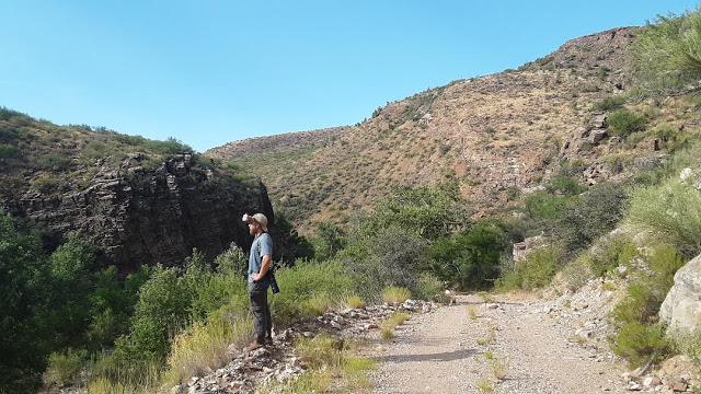
-Ranch Creek Area: From the Highway 70 and Highway 77 intersection just east of Globe, head east on Highway 70 for 5.2 miles, where there will be a turnoff to a road heading off in the southeast direction (this is just past the small San Carlos Airport). Turn south on this road (labeled as Coolidge Dam Road) and follow it south a short distance for 0.2 miles, and then take the first right turn in the southwest direction. The road, labeled as Ranch Creek and Road 700, parallels Ranch Creek for most of it's length. This road can be followed for about 9 miles, but it gets extremely rough after the first few miles when the road crosses Ranch Creek. Do not attempt to drive on this road without a jeep or truck with plenty of high clearance. This is a location that is worth exploring if one can drive the route or hike in for a distance. Ranch Creek is surrounded by upper Sonoran desert scrub in it's lower elevations and followed by juniper and chaparral slopes with increasing elevations. The creek itself has a good riparian system and is composed highly of sycamore, but it also has stands of cottonwood and willow trees. There are sections along the creek that are in midst of scenic, rocky canyons. This area was explored in summer of 2018 (Caleb Strand and Tommy DeBardeleben) in search of Buff-collared Nightjar. While this rare bird has been found fairly close to this area in Pinal County, the habitat along Ranch Creek was suitable for the bird. In the search, no Buff-collared Nightjars were detected, but a variety of bird life included Black-chinned and Costa's Hummingbirds, Common Black-Hawk, Zone-tailed and Cooper's Hawks, Western Screech, Elf, and Barn Owls; Common Poorwill, Northern Beardless-Tyrannulet, Brown-crested and Ash-throated Flycatchers, Bell's Vireo, Juniper and Bridled Titmouse, Woodhouse's Scrub-Jay, Verdin, Rock, Canyon, Cactus, and Bewick's Wrens; Crissal Thrasher, Black-throated and Rufous-crowned Sparrows, Canyon Towhee, Hooded Oriole, Lucy's Warbler, and Summer Tanager.
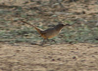
-Peridot Mesa: From the Highway 70 and Highway 77 intersection just east of Globe, head east on Highway 70 for 14.3 miles and turn off onto a dirt road that has a wide parking area at the base of it's entrance. This dirt road is also 2.7 miles west of Peridot via Highway 70. Head north on this dirt road toward Peridot Mesa through open desert for 0.6 miles, take a right turn at the fork, and then take this right fork for a mile or over up and onto the Peridot Mesa. From here, several different roads can be taken throughout the Mesa. The best approach is to park and walk around to explore, as the habitat on the Mesa is an interesting one to bird. While it has desert surroundings, Peridot Mesa is flat and full of weeds, wildflowers, and scattered desert-scrub. This area has a grassland look and feel to it, even though it is not a true grassland. Raptors will utilize the habitat, and Gila County's first known White-tailed Kite was found here (Caleb Strand). Look for species like meadowlarks, Lark Bunting, a variety of sparrows, and Sage Thrasher.
Tufa Stone Tank and San Carlos River to Talkalai Lake
For the next few locations, a specific intersection in the town of San Carlos will be the base point for directions. From the Highway 70 and Highway 77 intersection just east of Globe, head east on Highway 70 for 17 miles to the turnoff on the north side (left) of Highway 70 at Peridot, which is signed off as "San Carlos Lake Recreation Area". After the left turn, head north on AZ-170 N for 3.9 miles to Pinal Street (which is also AZ-170 N when turning west on Pinal St). The intersection of AZ-170 N and Pinal Street will be the base point for the directions. On another note: on the way to the base point while traveling north on AZ-170, access to the San Carlos River is possible 1.9 miles north of Highway 70. Turn east on Peridot Siding Road to find a few pull offs before and just west of the San Carlos River. The San Carlos River is hard to navigate in almost all of it's access points due to tremendous undergrowth below dense cottonwood and willow forest that line the river. There is great birding potential along the river despite the difficulty in access. Also, the western side of the San Carlos River is Gila County and the eastern side of the river is Graham County.
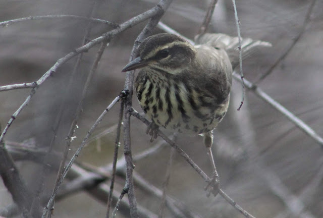
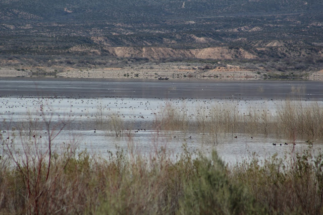
-Tufa Stone Tank: When it has water, Tufa Stone Tank is one of the best birding locations in all of Gila County. In fact, it may just be the best (time will tell.) From where AZ-170 meets Pinal Street, head west on Pinal Street for 0.1 mile to Apache Avenue. Turn right and north onto Apache Avenue for 0.3 miles to Tonto Street. Turn west/left onto Tonto Street for 0.9 miles in the northwest direction to BIA Road 903. Turn left/west onto BIA Road 903, still heading in the northwest direction. Follow BIA Road 903 (which starts out paved and quickly turns to dirt) for 1.1 miles until there is a dirt road that branches off to the left. Take this left road for 0.2 miles to the southwestern direction and park before and just east of Tufa Stone Tank. Several washes flow into Tufa Stone Tank, and the tank also has a dam that streches across it's southern perimeter. The road also extends over the dam and there is also a parking area on the west side of the tank. Tufa Stone Tank is surrounded by open desert that is highly populated by creosote. The surroundings make the area seem dull until the tank is accessed. There are times when the tank has water, and times when it is dry. When there is water present, the location may be a mecca of a birding spot. There are a few patches of willow and cottonwood trees on the north side of the tank, weedy and grassy sections on the west and east sides of the tank, and also neighboring the immediate area of the tank are dense mesquite woodlands. There is also a path that starts at the west side of the tank and travels south of the dam through mesquite bosque toward a small stand of cottonwood and willow riparian woodland. When water is present at the tank, bring an old pair of shoes to get wet to get the best results out of an exploration. Also when there is water at the tank, spring, fall, and winter hold very high potential. In the early stages of fall 2018, Tufa Stone Tank was knowingly birded for the first time and there was water. In the early expeditions by several observers, there were 70 or more different species here during each visit. This included a variety of migrants (passerines and non-passerines, including more than 10 species of shorebirds) and resident birds. Between fall and early winter of 2018 and spring of 2019, highlights that have been discovered here so far have included Greater White-fronted Goose, Red-breasted Merganser, 15 species of shorebirds, Common Tern, Golden Eagle, Long-eared Owl, Lawrence's Goldfinch, Cassin's, Grasshopper, and Clay-colored Sparrows; Sagebrush Sparrow (very few records for Gila County), Northern Waterthrush, Black-and-white Warbler, American Redstart, and Dickcissel. For birders who are visiting the much more popular San Carlos Lake, Tufa Stone Tank is a good to great place to stop and check before or after a lengthy scan of the large reservoir.

-Talkalai Lake: Talkalai Lake is a smaller and pleasant reservoir northeast of the town of San Carlos, and it is in both Gila and Graham Counties. From the AZ 170-N and Pinal Street intersection, head east on Pinal Street for a very short distance where it turns into White Mountain Avenue. Stay on White Mountain Avenue for 1.9 miles. At 1.9 miles, turn right and to the northeast on an un-signed paved road. Follow this road to the north for 0.6 miles to a dirt road on the right, and take the road east and northeast. This dirt road is Road 1110, and it goes for 2.5 miles to Talkalai Lake. Once turning onto Road 1110 from the un-signed paved road, there will be several side roads that veer off from Road 1110. The route is generally easy to follow, but keep left at 0.5 miles, keep left at 1.1 miles, stay right at 1.6 miles, and after climbing in elevation for a short distance, the road will drop back down to the elevation and will parallel Talkalai Lake. Continue past the first road fork, followed by passing the picnic tables and stay headed down in the southeast direction to where the road is close to the lakeside habitat and ends at the lake. Another road bends to the southwest and goes closer to the dam. Talkalai Lake is surrounded by desert habitat that is dominated by cresote, but the lake has great marsh and cattail habitat, as well as stands of cottonwood and willow trees along it's perimeters. The route that Road 1110 goes along and ends at the northern side of Talkalai Lake is in Gila County. Graham County has the south side of the lake, and the open water is divided between the two counties. The northern two thirds of the lower and wider arm of the lake are in Gila County, as well as the extreme western line of the upper arm. Most of the entire upper arm and lower third of the lake are in Graham County. San Carlos Lake flows into Talkalai Lake north of the lake and of course, south of the dam. The lake will attract a variety of waterbirds, Bald Eagles, and passerine migrants. It is a good spot in Gila County to get Sora, Virginia Rail, Common Gallinule, and perhaps the only spot to detect Least Bittern. The area also seems to have Northern Beardless-Tyrannulet quite regularly.
-San Carlos River below Talkalai Lake Dam: Trace back to the starting point with the directions to Talkalai Lake. Once turning onto Road 1110, take 1110 for 1.1 miles and turn right (south) toward the San Carlos River. Go left/east at the intersection of two dirt roads and park where the road shortly ends. The riparian stands of willow and cottonwood with surrounding mesquite bosque can be birded here along the river. At this point, the west side of the river is Gila County and the east is Graham. Migrations may be very productive. Go east of the parking spot along a trail that goes close to Talkalai Lake Dam. This is a good spot along riparian habitat, and Northern Waterthrush has been found here before. Go back to the parking area and intersection of the two dirt roads. Head slightly southwest through a mesquite bosque and to various points along the river. Several roads go further west and cross the river to give better access to the densely vegetated habitat of the San Carlos River that is extremely hard to navigate. Brown Thrasher and Swamp Sparrow have been found near the river, and Northern Beardless-Tyrannulet has been found in the mesquite bosque.
San Carlos Lake Area
From the Highway 70 and Highway 77 intersection on the east side of Globe, travel east on Highway 70 for 17 miles. Turn left at Peridot onto AZ 170-N/Coolidge Dam Road, where there is a sign that is signed off for 'San Carlos Recreation Area'. Turn right and south on Coolidge Dam Road (which is also known as Indian Route 3) and proceed to San Carlos Lake. More specific directions will be given in reference to this specific point in the following birding locations. Also, if coming on Highway 70 from the east and heading west toward San Carlos, this intersection is 57.5 miles west from the town of Safford.
-San Carlos Sewage Ponds and agricultural fields: Head south on Coolidge Dam Road for 2.1 miles past Highway 70. On the east side of the Coolidge Dam Road, look for the fenced off sewage ponds on the east side of the road. Park and look and listen for birds in the wetlands from the road, do not enter this location beyond the fence. This is a good location to hear both Virginia Rail and Sora, Common Gallinule, and other marsh birds. On the west side of the road, tall mesquite and other desert vegetation harbor a variety of birds. This would be a good spot to look for migrants. Pyrrhuloxia, a bird that is rare in Gila County and is of uncertain status, is seen here occasionally. Just south of the sewage ponds are circular agricultural fields on both sides of the road that can't be accessed, that are worth scanning from the road. These fields attract a variety of raptors, such as Swainson's and Ferruginous Hawks.
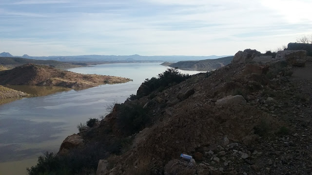
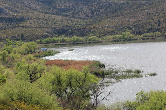
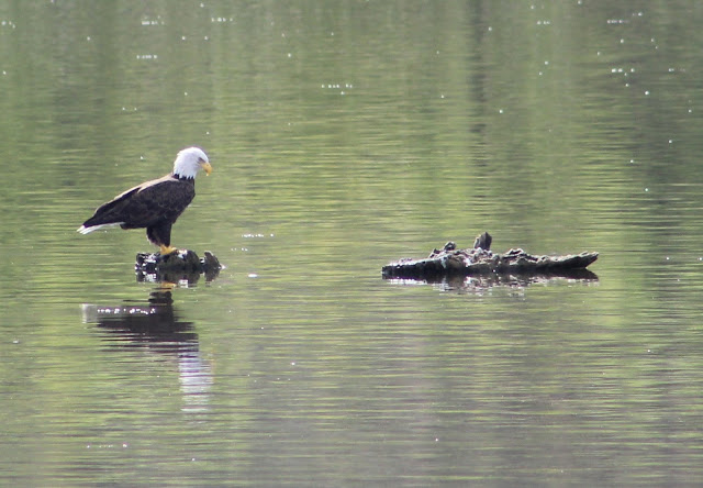
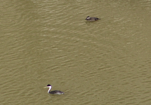
-San Carlos Lake: San Carlos Lake is one of the best birding locations in Gila County, Graham County, and Pinal County. For those who enjoy county birding, this lake is a fun one because the three mentioned counties each have significant enough portions of the lake where one can see a variety of waterbirds in each county. Out of the three, Gila County has the highest percentage of the reservoir. San Carlos Lake has a variety of water levels and a lot of inviting shoreline habitat for birds. It is a place to go to not only enjoy a lot of waterbirds of variety, but to discover rare and unusual bird species that find the lake annually. The lake is surrounded by a variety of desert scrub and canyons, and some willow and cottonwood riparian habitat along the San Carlos River at the east side of the lake. Western and Clark's Grebes breed here, as does Bald Eagle, and the lake often has high numbers of American White Pelican. When full, the lake has astounding numbers of wintering waterfowl. Sometimes counts of species exceed into thousands, and species like Canvasback may have numbers that go near or even over a thousand. Rarities that have been discovered at the lake have included Pomarine and Parasitic Jaegers, Arctic and Least Terns, Laughing, Heerman's, and Iceland Gulls; White-winged and Surf Scoters, Tundra Swan, Roseate Spoonbill, Whimbrel, Red Phalarope, and Rough-legged Hawk (not all of these records have been from the Gila County side of the lake). Doug Jenness and Keith Kamper are two birders who have spent a great amount of time birding this lake and gathering knowledge up about it's bird life. They have found a lot of rare birds at the lake, including some of the meintioned ones.
Directions: From Highway 70, take Coolidge Dam Road (Indian Route 3) south and toward San Carlos Lake. There are several places along the route that have dirt roads leading to the north side of San Carlos Lake, found on the east side of Coolidge Dam Road. One of them is at 2.7 miles, and that eventually travels to the San Carlos Monument. On this guide, access points on the south side of San Carlos Lake from Pinal County (but looking north into Gila County) will be described in detail, and the northern ones will be put on hold. The northern ones have much rougher roads and are difficult to access without a vehicle that has great clearance. A link to a more-in-depth article of the lake, written by Doug Jenness, will be included at the end of the San Carlos Lake description (scroll down). Indian Road 510, which is accessed from the east side of Coolidge Dam Rd/Indian Route 3 at 6.6 and 7.2 miles south of Highway 70, accesses several roads that branch off to the south of 510 within a five mile stretch and travel south to the north shoreline of San Carlos Lake for about two miles.
From Highway 70, take Coolidge Dam Road 9.4 miles south to Soda Canyon Road. Head south on Soda Canyon Road for about a mile to it's ending point. This road ends at a boat launch and picnic area. It overlooks the northwestern side of San Carlos Lake, and this is an easy access point to a location that is on the north side of the lake and in Gila County. This section of the lake often has lower water levels near the shore and birds will congregate on small islands out on the lake or along the shoreline. About halfway out on the water is the county line of Gila and Pinal, with Pinal being the southern half of the lake.
The main reference point to birding San Carlos Lake will be from Coolidge Dam, which is at the westernmost side of the lake. To reach Coolidge Dam, take Coolidge Dam Road (Indian Route 3) for 11.8 miles south of Highway 70 in Peridot. The waters are deep near the dam, and harbor diving species like Western and Clark's Grebe. Surf Scoter has been seen here before. From here, San Carlos Lake extends to the east for a considerable distance. As a rule of thumb for county listing, most of the northern half of the lake is in Gila County for the lake's entire length, the southern half is Pinal County up until going east of County Line Road, and the southern half of the lake east of County Line Road is Graham County to the very eastern side of the lake, with Gila County still averaging to be the northern half of the lake adjacent to Graham County.
*Birding San Carlos Lake from Coolidge Dam
Directions will now be described in accordance to distance of driving east of Coolidge Dam on Coolidge Dam Road/Indian Route 3. This road will be the base to accessing San Carlos Lake and will be ground based in Pinal and Graham Counties. Many roads that branch off to the north of Indian Route 3 give access to San Carlos Lake. Most of them aren't labeled in the field, and some names can be found on Google Maps. Even though the lake will be scanned from these other counties, Gila County is still accurately viewable to the north with a scope. A high clearance vehicle is strongly recommended for driving on these dirt roads toward the lake. Use extreme caution, as there is a lot of loose soil in portions along some of the branch off roads from the main road, where it doesn't take much to get stuck. It would take a lot to describe directions to all the forks of these north-branching roads. When at the lake, cell phone reception comes in in areas and is very helpful for additional navigation.
-The first stretch of going east past the dam on Indian Route 3 has plenty of roadside pull offs where the lake can easily be scanned from. One productive road that goes north of Indian Route 3 is at 2.9 miles east of the dam, which is Road 571. Follow it to several lookout areas that a selection of different forks provide that give great views of the lake. Some streches and forks from Road 571 can go for about two miles north of Indian Route 3.
-Road 572 branches north of Indian Route 3 at 3.2 miles. It has a few forks that lead to different viewpoints for up to a mile north of Indian Route 3.
-At 4.1 miles, 4.4 miles, and 4.5 miles are three more roads that branch off north of Indian Route 3 toward San Carlos Lake from one to two miles.
-At the road that is at 4.5 miles, take it north for 0.6 miles and take another road to the right. This road that is taken right from the fork is County Line Road. Travel it for 0.2 miles, keeping right at another fork, and then proceeding another 1.2 miles or so northward. This road straddles the Pinal and Graham County line, and it leads to a very productive section of San Carlos Lake that often has shallower waters and a high variety of species. The junction of Gila, Pinal, and Graham Counties are close to this location, and going further east one will be in Graham County.
-At 7.9 miles on Indian Route 3 east of Coolidge Dam, is another road that heads north for 0.6 miles in Graham County that has a great overlook towards the eastern side of the lake.
-At 8.7 miles east of Coolidge Dam on Indian Route 3, take another road north. This road goes for over a mile to Quail Springs Boat Launch, and it is a great place to observe a variety of waterbirds in both Graham and Gila Counties.
For San Carlos Lake, there is much to see and explore. For this guide, the descriptions are kept more brief. To read a much more detailed description of San Carlos Lake along with maps of boundaries and roads, check out this excellent article that was written by Doug Jenness at the link HERE (There are several published articles on the AZFO website, Doug's is the second one from the top).
Indian Route 1500 and Warm Springs Flat
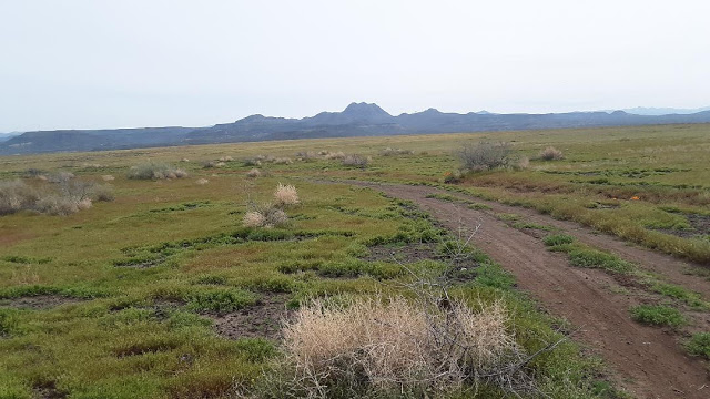
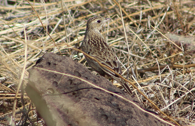
This area has sections of grassland habitat that are on plateaus, and with Gila County being limited on it's grassland habitat, these locations are an important visit. The area is reached by taking Highway 70 for 22 miles past it's intersection with Highway 77 at the east side of Globe and turning north on Indian Road 8 on the north side of Highway 70. This spot is also 5 miles east of Peridot adjacent to AZ 170-N and Coolidge Dam Road. Take paved Indian Road 8 (which is in Graham County) north and east for 14.5 miles to Indian Road 1500. Turn left and north onto Indian Road 1500 (which is still in Graham County and is a dirt road that is in good shape) for 3.5 miles to the San Carlos River. There is a good riparian habitat along the river here that is worth exploring. The north side of the river becomes Gila County, and once the river is crossed, Indian Road 1500 goes completely into Gila County. This section of Gila County elevates onto a plateau that holds habitat of semi-arid desert grassland and some Chihuahuan desert. It is a location that has a ton of potential and needs to be birded more. The grassland habitat has some wide sections of grass, that has mixes of both grass and weed. Grassland species such as longspurs, Sprague's Pipit, Short-eared Owl, Rough-legged Hawk, and Ammodrammus sparrows should be kept in mind here. From the San Carlos River crossing, proceed on Indian Road 1500 for 3 miles, and there will be a large grassland area on the west side of the road, with Chihuahuan desert scrub on the east side of the road. Grasshopper Sparrows have been found here in the grassland, as well as Gila County's first known Sprague's Pipit (Caleb Strand). Gila County's first known Scaled Quail was also found in the desert scrub (Caleb Strand) and further investigation resulted in the quail numbers jumping to 32 birds (Caleb Strand, Felipe Guerrero, Tommy DeBardeleben). At 4 miles past the San Carlos River crossing, Indian Road 1500 comes up to the Rocky Junction intersection. Turn right to stay on Indian Road 1500, but go left to access more smaller grassland areas on Indian Road 1200. Not far east of this area and in Graham County is the much larger grassland area of Ash Flat, which already has a lot of greatness to it's location with discoveries by Felipe Guererro. More birding in this area might prove Warm Springs Flat and company to be considered a great location in Gila County.
Back to Gila County Birding Areas |