Morgan City Wash Maps
*All maps property of Google.
Map # 1: Turnoff and parking access to Morgan City Wash
This maps shows the overview to the entrance and where parking access is to access Morgan City Wash. The parking is actually by the Agua Fria River to start off, which Morgan City Wash is a little west of the parking lot and forks into the Agua Fria River. The Morgan City Wash trails are found well west of the parking area. This short parking road can be found 2.4 miles east of the turnoff to Lake Pleasant Regional Park. If on Highway 74, this turnoff will be at mile marker 22, and the road one will turn off is signed as Beardsley CSR Road. Take Beardsley CSR Road north a short distance to where parking is located. By the parking area is a point in the road that turns sharply to the right, don't go beyond the parking area point east any further, it's a no tresspassing area.

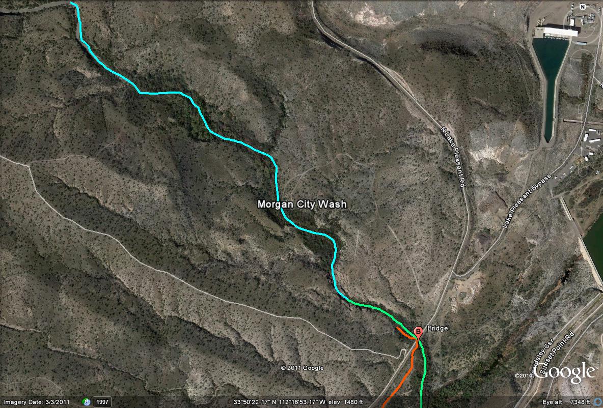
Map # 2: Overview of hiking access, as well as where Morgan City Wash and Agua Fria River stand
This map shows a few things you should know when birding at Morgan City Wash. The first is the Agua Fria river, which is all bushwacking through thick vegetation in order to explore this section, which is highlighted by the green path/line on this map. It's an excellent section and is one of the most productive when birding in this area. Morgan City Wash is shown at it's south limits on this map, highlighted by the light blue line/paths, where it meets the Agua Fria River eventually. The easiest hiking the Morgan City Wash area has to offer is accessed just west of the bridge (Old Lake Pleasant Road), where there have recently been excellent trails built to provide great access to the wash. By finding the bridge, these trails have become very noticable just west of the bridge, running for over a miles length from the bridge through Morgan City's excellent riparian habitat in the northwest direction. The trails form loops at points. For birders not familiar with the area, this is the best choice to take, which passes through great and equal habitat the entire area has to offer. The bridge can be found northwest of the parking lot which runs over Morgan City Wash. It can be tricky to find it, but by following the orange path shown on this map, the bridge can be reached. With Old Lake Pleasant Road on the west side of the hiker, you will eventually come across the bridge, which crosses the wash. Shortly once on the west side of the wash, are the trails. Once this can be found, the birding and hiking is rather easy.
TO REACH THE BRIDGE: Once parking, follow the the noticable path by the parking area west (which is shown as an orange line on this map) for a short distance. Once it curves to the southwest, there is a line of tamarisk trees one will have to go through to continue along this path to reach the bridge. There is a path going through the tamarisk close to this spot (which can be hard to find), which takes you to a path on the other side of the tamarisk, which is the easy path to follow that reaches Morgan City Wash and the bridge. One will have to go under a gate to reach the side of this trail to the west of the tamarisk, which is relatively easy. This gate outlines the path which is in the Agua Fria River channel.

Map # 3: Morgan City Wash overview of the excellent riparian habitat.
The light blue path illustrates and shows Morgan City Wash during the great stretch of riparian habitat, which is almost a full mile in length west of the bridge.
|