"Foxtail/Sheep's Crossing stretch" Recreation Site
Fast Flight Facts
Target Species: Desert Riparian bird species
Elevation: 1400'
Habitat: Desert Riparian Habitat along the Salt River
Overall Birding Rating: 5
Difficulty: 3 (Moderate)
Birding Type: Moderate Hiking
Facilities: None
Fees/Ownership: None, part of the Tonto National Forest
Closest Town or City/How far from Phoenix: Mesa /29 miles east-northeast of Phoenix
Getting there: Accessed by hiking to the area on a dirt road after parking along the Bush Highway
Overview: The "Foxtail/Sheep's Crossing stretch" Recreation Site is more unknown along the Salt River, but is one of the best places the area has to offer. The habitat is excellent along this stretch, and there are different names that would perhaps be more appropriate for this site than this name given on here. The area lies between two recreation sites that are now closed to vehicle use. Those two recreations sites are the Sheep's Crossing and Foxtail Recreation Sites. There are signs still for Sheep's Crossing behind closed gates, but Foxtail is and always was unsigned. The Foxtail Recreation Site can be read about in Mike Rupp's book, Bird's Eye to 101 Birding Sites-Phoenix. There is about 1.5 miles separating the two recreation sites, with the area of the old Foxtail Recreation Site being on the west and the Sheep's Crossing Recreation Site being on the east. However, the best access to the area is located just west of the Sheep's Crossing Site on a closed road that only permits foot travel located directly across from the Great Western Trailhead. By following this other access road a short distance to the Salt River, there are two directions to go. Both west and east from where the access road branches off has excellent habitat, consisting of many willows and mesquites, some cottonwoods, and great sonoran desert habitat. The mix of habitat gives birders another good spot with great bird and habitat variety along the Salt River, in a place that is very unknown and peacefully quiet.
The best birding aspect of this site would be a smaller but very productive wash that is heavily lined with willows, giving it a good name, "Willow Wash". Willow Wash forks just to the east once reaching the west or east forks of this location from the main access road. Sometimes the Salt River will flow through the wash (during tubing season) and the wash will have to be birded from the sides. It does create a lush environment and is attractive to many birds. Warblers during migration here are diverse, as well as other songbirds. Good mesquite bosque as well as several cottonwoods are found throughout this area. By walking west from the access road along the Salt River, more good willow habitat is along the river, although it is more spread out. The mesquite and sonoran desert habitat is much more prominent along this stretch. Water levels of the Salt River vary here, as there are good spots to view shorebirds such as Spotted Sandpipers and Greater Yellowlegs. There are also deeper parts or the river that will support ducks like Common Mergansers in good numbers. Across from the river on the north side, are taller cottonwoods and many snags, making it a good raptor viewing bet, often for Bald Eagles. When birding here, prepare to see a great variety of birds, especially during the migration periods.
Birding Tip: Once parking at the Great Western Trailhead and walking north across the Bush Highway to the Salt River, bird the area thoroughly. Bird the entrance road, which has great mesquite habitat. After a short distance on the entrance road, the road goes in both directions, forking to the west and the east. The noticeable wash full of willows ("Willow Wash") is immediately east and runs 0.4 miles and ends up very close to the Sheep's Crossing Recreation Site.. Bird that wash, which will have a good variety of warblers and other songbirds in during migrations. The good habitat ends a short distance once "Willow Wash" reaches it's end. After exploring the east side, continue well west a good distance, where the actual Foxtail Site is. By exploring this area well, one shall have an excellent birding day in this area!
Directions: Access to this area is located between the Goldfield and Blue Point Recreation Sites (active recreation sites). It lies much more closer to the Blue Point Site, a little west. Access to this stretch will be between mile markers 28 and 29. Keep an eye out for the Great Western Trail, which is on the south side of the Bush Highway at this point. It is a noticeable dirt parking area pull off, and once parking here, cross the highway so you'll be on the north end of the road. Walk a short distance west to see a dirt road that is closed off by a fence. No vehicles are permitted to drive this closed road, but hikers are. Walk back in on this path to explore this great area, where the paths will fork to the east and west. Refer to the maps under the "Pages" section on this page for a better visual idea for birding this site.
Pages:
"Foxtail/Sheeps Crossing stretch" Maps
Foxtail/Sheeps Crossing Recreation Sites eBird Data
Scenes and Sights from the "Foxtail/Sheep's Crossing stretch":


"Willow Wash"
Dry months..


"Willow Wash"
Wet months...


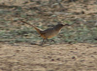
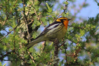
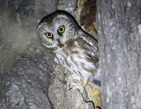
Birdlife of the "Foxtail/Sheep's Crossing stretch":
Northern Waterthrush (uncommon migrant-this one visiting Willow Wash)

Green-tailed Towhee

Back to Area 2-Lower Salt River Recreation Area |